


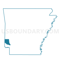
Jefferson Voting District, Sevier County, Arkansas
About
Outline

Summary
| Unique Area Identifier | 528200 |
| Name | Jefferson Voting District |
| County | Sevier County |
| State | Arkansas |
| Area (square miles) | 57.40 |
| Land Area (square miles) | 57.11 |
| Water Area (square miles) | 0.28 |
| % of Land Area | 99.50 |
| % of Water Area | 0.50 |
| Latitude of the Internal Point | 34.13972150 |
| Longtitude of the Internal Point | -94.16196370 |
Maps

Graphs
Select a template below for downloading or customizing gragh for Jefferson Voting District, Sevier County, Arkansas


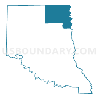
Neighbors
Neighoring Voting District (by Name) Neighboring Voting District on the Map
- Bear Creek East Voting District, Sevier County, AR
- BLUE RIDGE Voting District, Howard County, AR
- BURG Voting District, Howard County, AR
- DUCKETT Voting District, Howard County, AR
- Grannis Voting District, Polk County, AR
- MADISON Voting District, Howard County, AR
- Mineral North Voting District, Sevier County, AR
- Mineral South Voting District, Sevier County, AR
- Saline East Voting District, Sevier County, AR
- Saline West Voting District, Sevier County, AR
- UMPIRE Voting District, Howard County, AR
Top 10 Neighboring County Subdivision (by Population) Neighboring County Subdivision on the Map
- Bear Creek township, Sevier County, AR (8,262)
- Ozark township, Polk County, AR (2,475)
- Madison township, Howard County, AR (1,564)
- Mineral township, Sevier County, AR (1,086)
- Saline township, Sevier County, AR (251)
- Umpire township, Howard County, AR (251)
- Blue Ridge township, Howard County, AR (193)
- Jefferson township, Sevier County, AR (141)
- Burg township, Howard County, AR (61)
- Duckett township, Howard County, AR (58)
Top 10 Neighboring Unified School District (by Population) Neighboring Unified School District on the Map
- De Queen School District, AR (11,059)
- Wickes School District, AR (3,273)
- Dierks School District, AR (2,915)
Top 10 Neighboring State Legislative District Lower Chamber (by Population) Neighboring State Legislative District Lower Chamber on the Map
- State House District 21, AR (27,003)
- State House District 22, AR (26,644)
- State House District 23, AR (26,178)
Top 10 Neighboring State Legislative District Upper Chamber (by Population) Neighboring State Legislative District Upper Chamber on the Map
Top 10 Neighboring 111th Congressional District (by Population) Neighboring 111th Congressional District on the Map
Top 10 Neighboring Census Tract (by Population) Neighboring Census Tract on the Map
- Census Tract 9501, Howard County, AR (4,108)
- Census Tract 801, Sevier County, AR (3,778)
- Census Tract 9506, Polk County, AR (2,432)